It’s a quick 64 kilometres from Inverell to Glen Innes along the Gwydir Highway. That’s about 20 minutes on the BMW GS R1200 I was riding yesterday. Just kidding, officer.
But we’re tooling about on a posse of brand new BMWs and going the direct route would be like taking the Starship Enterprise to Woolworths. Instead, after breakfast in Inverell, we head north on one of the smaller roads towards Ashford and beyond, to where it joins the Bruxner Highway.

It’s pancake-flat country out here, our journey spearing through wide open vistas. There are also a few unsealed sections, which some of our more experienced riders take the opportunity to test.
Above us is a Simpsons sky, all cobalt blue and fluffy cloud mountains, not too cold and not too hot. It’s perfect biking weather on roads that are surprisingly well maintained and largely free of traffic.
We join the Bruxner Way at the Long Flat T-junction and turn right towards Tenterfield. The Bruxner runs from the Northern Rivers region and, at least until Tenterfield, pretty much hugs the border with Queensland. After Tenterfield, it parts company with Qld and heads east to Casino, wiggling up and over the Great Dividing Range on the way.

We join the Bruxner Highway heading towards Tenterfield. We’re not ready to head back to the coast just yet so the plan is to check out the Tenterfield Saddler, the saddlery made famous in the song by the late great Peter Allen, and then take the New England Highway south to Glen Innes.

The Saddler is tucked away in a side street in town and is a curious mixture of country life and showbiz, where animal skulls rubs shoulders with pictures of Liza Minnelli and in the front window cans of leather dubbing share the limelight with a pair of Peter Allen’s snazzy red show shoes. The Tenterfield Saddler is well worth the stop.

It’s here at Tenterfield that you can try the Mount Mackenzie Drive, a short gravelly, off-road circuit up and around the mountain that looms over the town. If you make it to the top in one piece (some didn’t) the panoramic views are worth every minute (I’ve seen the pics). You can also pretty much lean over and shake hands with Queensland from there.

While the others head off up the mountain (no off-road shenanigans for me) I head south along the New England Highway to Glen Innes. It’s a fairly straight road – none of the higgledy-piggledy Oxley Highway business here – through flat farming country but it’s a great opportunity to stop and take photographs. I spy just one kangaroo, but later riders report many more, especially at dusk.
Glen Innes, as you might expect from the name, was settled by a bunch of hardy Scottish people who thought the area, with its granite rocks, reminded them of home. For ‘hardy’ read ‘possibly insane’ because this would have been a horribly difficult place to reach in the 1830s – the history of which can be found laid out and explained in the local History House Museum.

Also known as the Land of the Beardies (after the name given to the original, bearded stockmen) the museum is situated in the town’s first hospital and is endlessly fascinating, showcasing everything from old farm tools to colonial bedrooms and real hobnail boots.
Just outside the main town centre there’s also a group of standing stones which was put up in 1992 to celebrate the town’s Scottish heritage and which forms the centrepiece of the town’s annual Australian Celtic Festival.


The Gwydir Hwy rolls through Glen Innes, head west towards Inverell or East towards Grafton, winding and switch-backing through the Washpool, Gibraltar Range and Barool National Parks.

About 30 kilometres outside town, the Old Glen Innes Road splits away from the main highway and detours south on gravel roads that follow the Boyd River through cattle country. Expect ghost towns and convict tunnels.

We hit the New England Highway again, aiming for Armidale where awaits us the unexpectedly impressive New England Regional Art Museum and a visit to the Saumarez Homestead, where manager Les Davis takes us on a whistle-stop tour of this venerable old pile.

We finish our tour the next day along the Waterfall Way, a 190-kilometre drive through the lower edges of the Guy Fawkes River National Park, taking in Dorrigo and Bellingen before ending in Coffs Harbour.

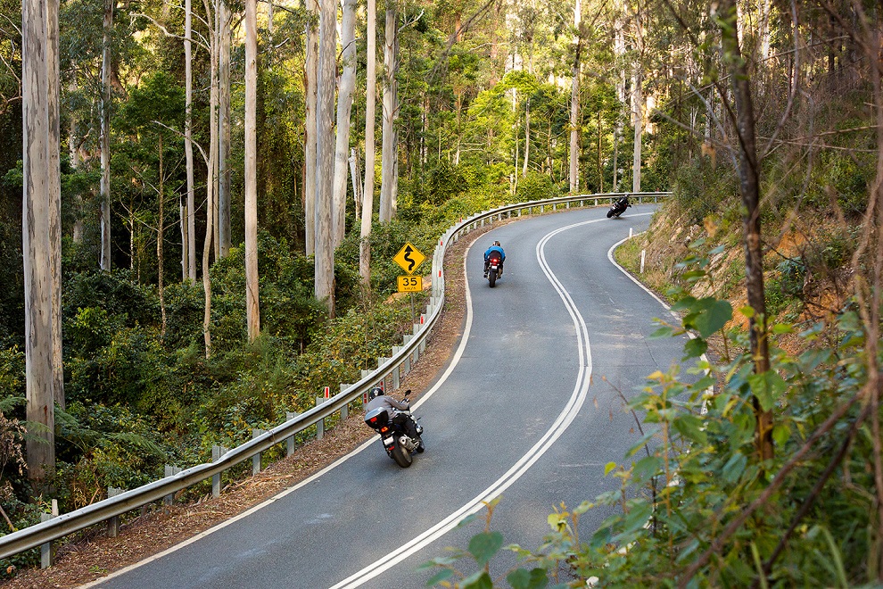
It’s a pretty drive, up and over the range to start with and then down the other side on tightly winding roads through shimmering green forests, hugging mossy cliff faces slick with water and waterfalls.
Waterfall Way is stunning road to ride with plenty of photo opportunities along the way. Stop, if you can, at Ebor Falls, which is pretty much the highest point over the range. The falls themselves are lovely and just a little further on, the Ebor Falls Hotel Motel is a bit of a haven for bikers.
After which, the final drive out is the perfect finish to our tour; swinging the bike confidently through turns I wouldn’t have attempted a few days ago and wondering when it would be seemly to swing by again. After all, this is a very big map…